Songwe Hill rare earths
Introduction
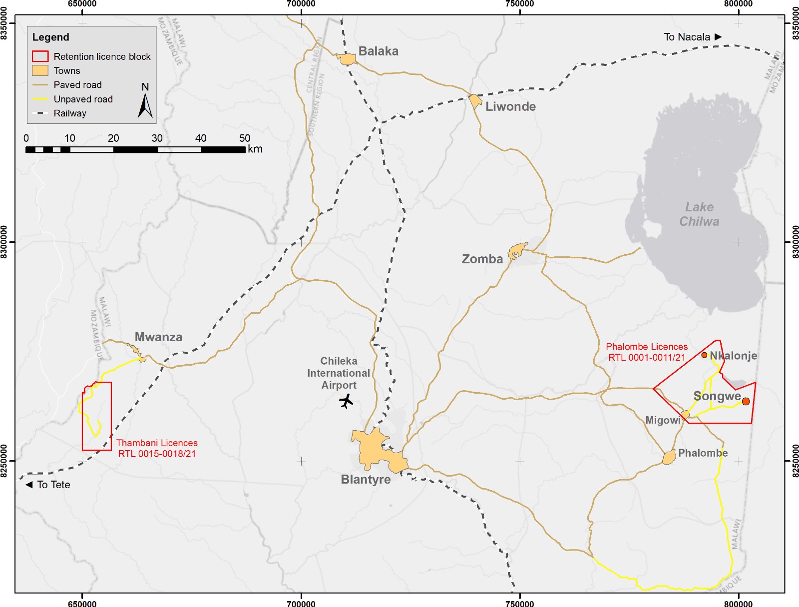
Songwe Hill, a carbonatite-hosted rare earth deposit, is the main development target in retention licence RTL 0001/21, one of a block of eleven retention licences which Mkango refers to as the 'Phalombe Licences'. Historical exploration programmes were carried out at Songwe Hill in the late 1980s. After three phases of exploration drilling in 2011, 2012 and 2018, Mkango completed a NI43-101 compliant technical report and upgraded Mineral Resource estimate for the Songwe Hill Project in January 2019, and the Definitive Feasibility Study was completed in July 2022.
Location
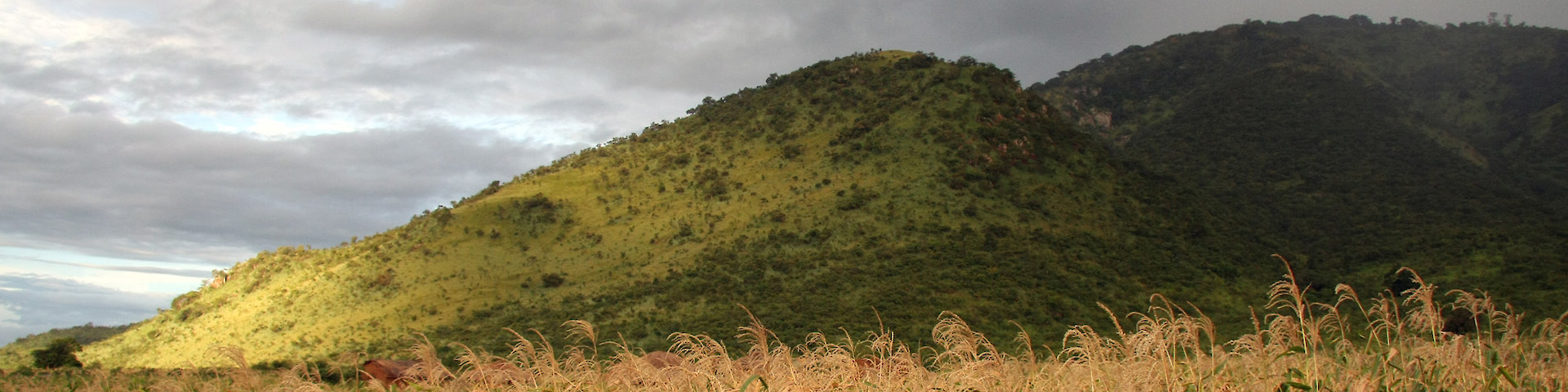
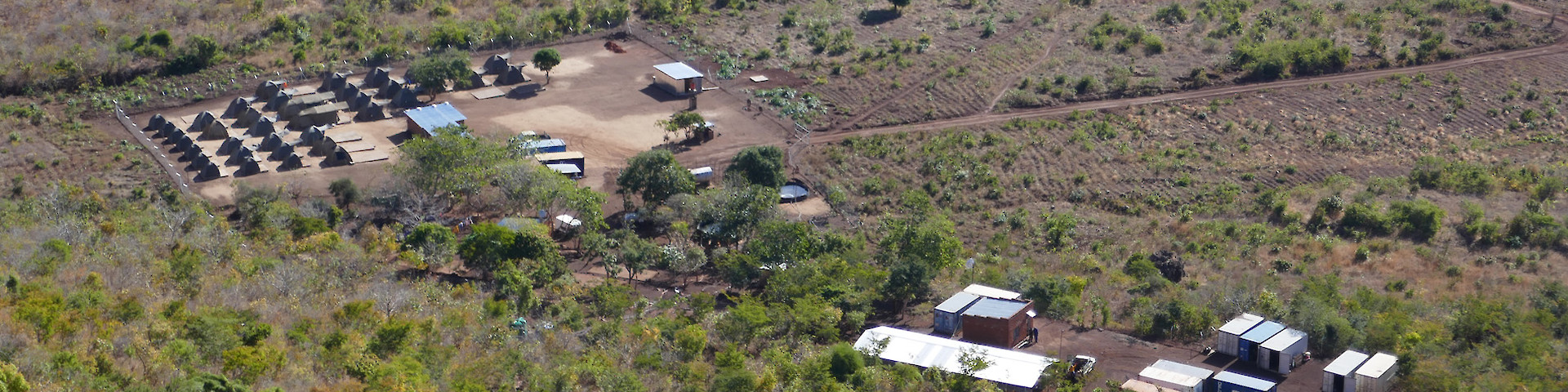
Songwe Hill is located in south-eastern Malawi, between Lake Chilwa and the Mulanje Massif, approximately 70km from the former capital Zomba and approximately 90km from the commercial centre of Blantyre, which has an international airport and a railhead. Paved roads run from the urban centres to within 12km of Songwe Hill. Secondary gravel and dirt roads provide vehicle access to the exploration camp, with recently upgraded bridges capable of taking 20-tonne trucks.
Geology and Mineralisation
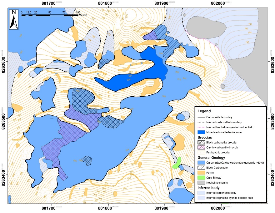
The principal lithologies are carbonatite, fenite, and breccias of fenite clasts with carbonatite matrix. The carbonatites are dominantly grey calcic carbonatites, although subordinate ferrocarbonatites are present. The fenites comprise dominantly K-feldspar rocks and form an aureole around the carbonatite and fragmented dykes within the carbonatite. They are interpreted to have formed through metasomatism related to the carbonatite intrusion.
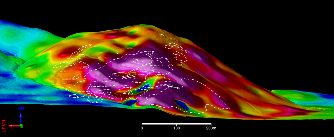
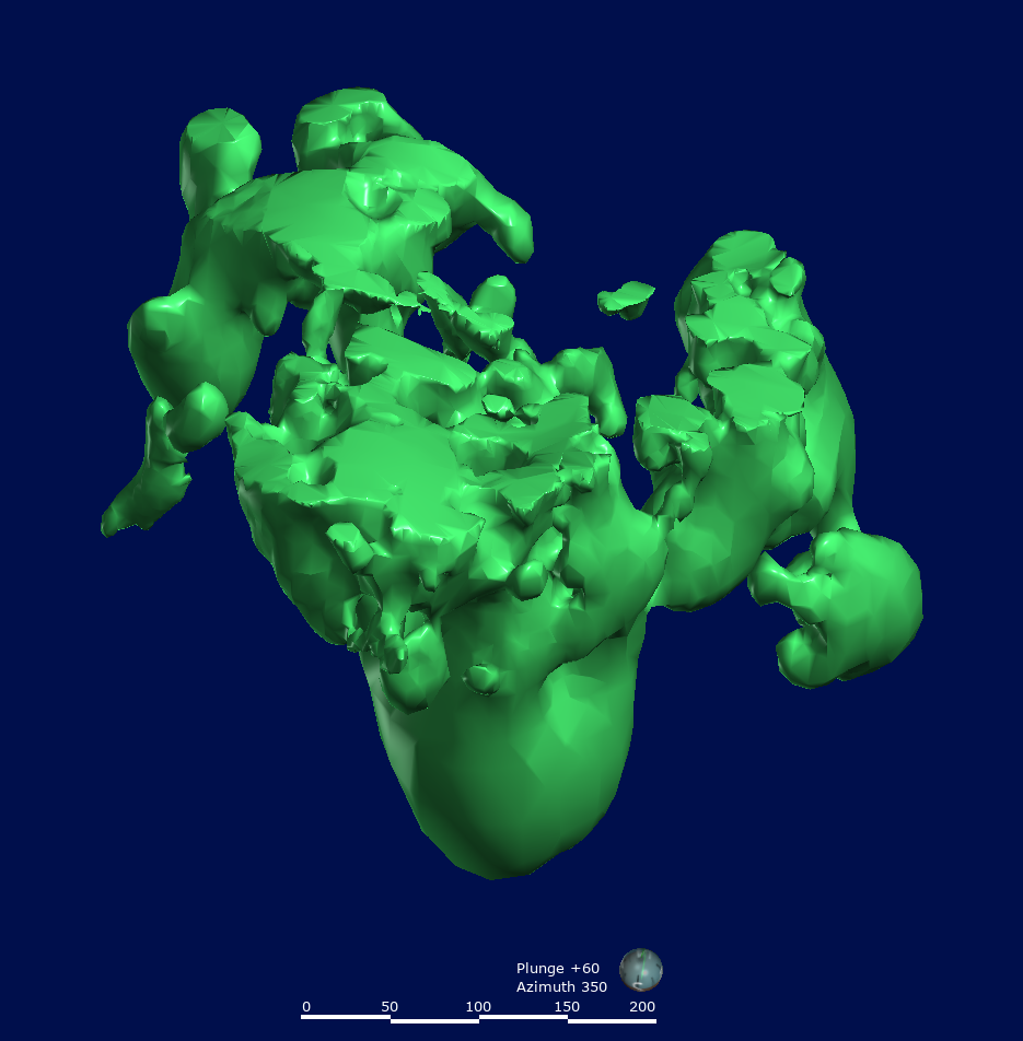
The rare earth element (REE) mineralisation occurs in the carbonatites, fenites and breccias. It is untested to the northeast and southwest beyond the limits of the present drilling and below the deepest vertical intersection of approximately 360m below the surface of the hill. The mineralised body is interpreted to be a carbonatite plug of which the central core has steep to subvertical margins.
The dominant REE-bearing minerals are synchysite and apatite. The apatite is anomalously enriched in the heavy rare earth elements (HREE) compared to apatites in most carbonatite deposits. The REE mineralisation is closely associated with strontianite and baryte and is interpreted to have formed through sub-solidus hydrothermal alteration following the carbonatite intrusion.
Exploration
Mkango has been exploring and evaluating the Songwe Hill rare earth deposit since January 2010. Following confirmation of the REE-enriched zones identified in the 1980s, exploration focused on identifying the nature and extent of the rare earth mineralised carbonatites and related rocks. Mkango’s early exploration activities consisted of lithogeochemical sampling, soil sampling, channel sampling, geological mapping, ground magnetic, gravimetric and radiometric surveys, and petrographic/mineralogical analyses.
Detailed geological mapping of Songwe Hill was carried out in 2010 and 2011, and demonstrated that carbonatite outcrops existed over a significantly larger area than had previously been recognised. Mapping further achieved a more precise delineation of the distribution of carbonatite, and not only broadened the surface area of known rare earth mineralisation beyond the areas identified in previous exploration, but also identified new areas of rare earth enriched carbonatite.
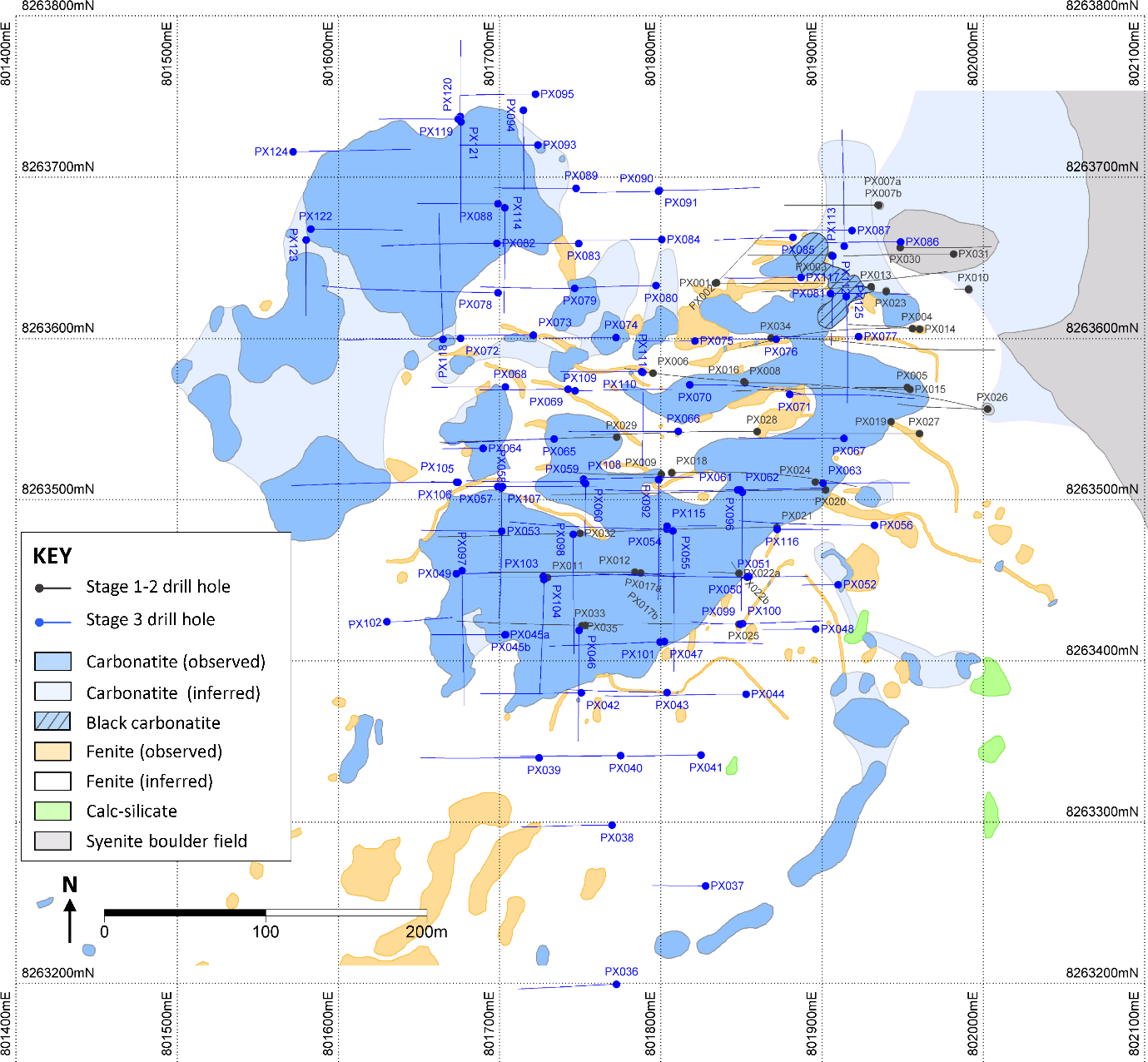
Mkango embarked on diamond drilling campaigns in 2011 (“Phase 1”), 2011–2012 (“Phase 2”) and 2018 (“Phase 3”). Phases 1 and 2 were the basis for the original resource definition. Phase 3 provided the basis for an updated and expanded resource which is incorporated in the Feasibility Study.
Drilling Results & Resource Upgrade
Following the receipt of £5 million ($7 million) in January 2018, pursuant to the transaction with Talaxis (see press release of 24 January 2018), Mkango commenced the Feasibility Study, the initial phases of which comprised the extensive Phase 3 diamond drilling programme, metallurgical optimisation and work relating to the ongoing Environmental, Social and Health Impact Assessment.
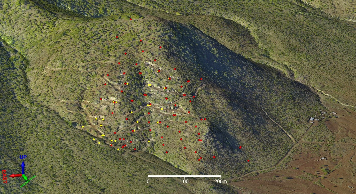
The Phase 3 drilling programme was carried out between June and September 2018, and comprised 91 drill holes totalling 10,900 metres of infill, step-out and geotechnical drilling, the latter for the purposes of mine design.
In five press releases between August and December 2018, Mkango announced the results of all 91 drill holes.
About fifty-five of the Phase 3 drill holes were infill holes aimed at better defining the geology and geometry of the mineralised body, to facilitate a better understanding of the geological characteristics and setting of the mineralisation, and to refine the geological model as a prelude to re-defining the Mineral Resource. All infill holes intersected significant widths of mineralised carbonatite and breccia. Modelling of the lithologies based on geochemistry confirms that the core of the deposit is a uniformly mineralised carbonatite intrusion with steep sides.
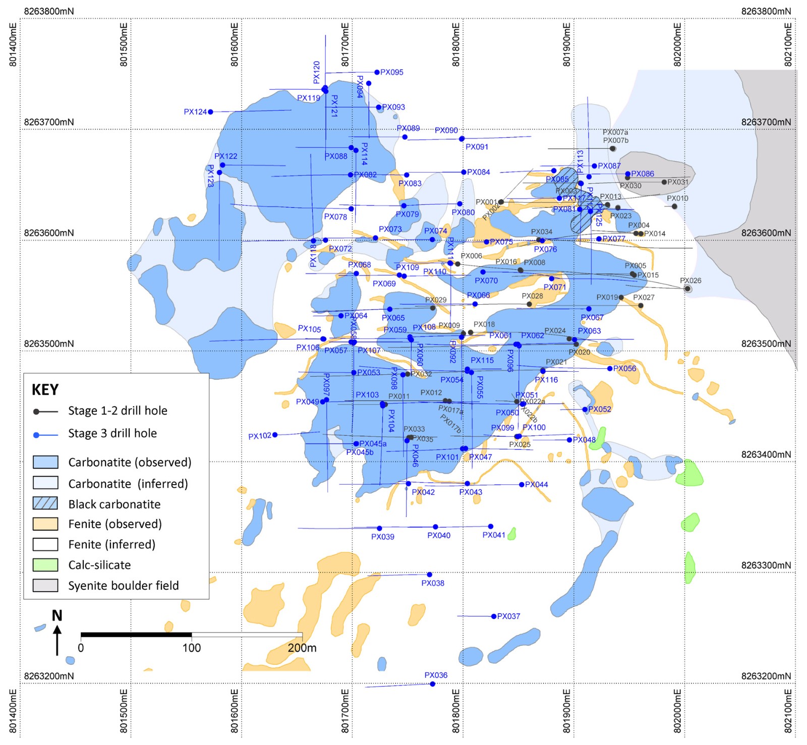
About thirty-six of the Phase 3 drill holes were step-out holes, most of which contained mineralised intersections although not all reached their targeted depths. These holes have resulted in expansion of the estimated Mineral Resources by identifying new areas of mineralised carbonatite beyond the limits of the previous exploration programmes.
Oriented core was recovered from 16 of the holes to provide geotechnical information within the Mineral Resource for mine design.
Forty-nine of the drill holes intersected zones of rare earths mineralisation grading above 1% total TREO. Intersections of broad zones of mineralisation, as opposed to narrow veins or dykes, continue to support the concept of a bulk tonnage, open pit mining operation with low mining costs. Highlights from the results include the following:
|
PX056 |
114.8 m grading 1.6% TREO (60.7 – 175.5 m) including 30.0 m grading 2.0% TREO (135.0 – 165.0 m). Inclined hole (60 degrees west). |
|---|---|
|
PX059 |
63.0 m1 grading 1.7% TREO (6.0 – 69.0 m), including 23.0 m2 grading 2.3% TREO (7.0 – 30.0 m), and 15.4 m grading 1.6% TREO (128.0 – 143.4 m). Inclined hole (60 degrees west). |
|
PX073 |
67.1 m grading 1.6% TREO (8.8 – 75.9 m) including 25.2 m grading 2.0% TREO (45.0 – 70.2 m). Inclined hole (60 degrees west). |
|
PX076 |
40.2 m grading 1.8% TREO (60.4 – 100.7 m) including 20.0 m grading 2.4% TREO (60.4 – 80.4 m). Inclined hole (60 degrees west). |
|
PX077 |
51.9 m3 grading 1.7% TREO (26.2 – 78.0 m). Inclined hole (60 degrees west). |
|
PX081 |
53.3m4 grading 2.2% TREO (3.7 – 57.0 m) including 26.8 m grading 3.1% TREO (3.7 – 30.5 m). Inclined hole (60 degrees east). |
|
PX086 |
73.3 m grading 1.9% TREO (21.5 – 94.8 m). Inclined hole (60 degrees west). |
|
PX087 |
74.4 m5 grading 2.1% TREO (16.2 – 90.6 m). Inclined hole (60 degrees west). |
|
PX090 |
25.7 m6 grading 3.9% TREO (39.5 – 65.2 m). Inclined hole (60 degrees west). |
|
PX092 |
74.9 m grading 1.9% TREO (10.1 – 84.9 m) and 51.9 m grading 1.5% TREO (97.6 – 149.5 m EoH). Inclined hole (60 degrees south). |
|
PX093 |
83.9 m grading 1.9% TREO (1.5 – 85.4 m) including 18.0 m grading 3.0% TREO (21.0 – 39.0 m). Inclined hole (60 degrees west). |
|
PX098 |
65.0 m7 grading 1.7% TREO (1.1 – 66.0 m) and 13.1 m grading 1.2% TREO (115.0 – 128.1 m). Inclined hole (60 degrees south). |
|
PX103 |
165.2 m grading 1.6% TREO (2.6 – 167.8 m). Inclined hole (60 degrees east). |
|
PX107 |
91.3 m8 grading 1.3% TREO (23.0 – 114.2 m) including 32.2 m9 grading 1.9% TREO (82.0 – 114.2 m). Inclined hole (60 degrees east). |
|
PX108 |
45.8 m grading 1.4% TREO (8.2 – 54.0 m) and 57.3 m grading 1.7% TREO (76.9 – 134.2 m). Inclined hole (60 degrees east). |
|
PX109 |
53.0 m grading 2.1% TREO (22.0 – 75.0 m) including 22.0 m grading 3.0% TREO (24.0 – 46.0 m). Inclined hole (60 degrees east). |
|
PX113 |
51.1 m10 grading 2.2% TREO (4.7 – 55.8 m). Inclined hole (50 degrees north). |
|
PX112 |
100.9 m grading 3.3% TREO (5.9 – 106.8 m EoH) including 20.5 m grading 4.2% TREO (5.9 – 26.4 m) and 22.2 m grading 4.1% TREO (36.0 – 58.2 m). Inclined hole (60 degrees south). |
|
PX125 |
104.5 m grading 1.5% TREO (3.5 – 108.0 m) including 51.5 m grading 1.9% TREO (3.5 – 55.0 m). Inclined hole (60 degrees south). |
Includes two cavities totalling 5.9m not sampled. 2 Includes a 2.5m cavity not sampled. 3 Includes a 2.7m cavity not sampled. 4 Includes a 3.8m cavity not sampled. 5 Includes a 2.7m cavity not sampled. 6 Includes a 6.3m cavity not sampled. Due to the size of the cavity, the significance of this intersection is uncertain. 5 Includes a 2.3m cavity not sampled. 6 Includes two cavities totalling 2.3m not sampled. 7 Includes a 0.9m cavity not sampled. 8 Includes two cavities totalling 10.0m not sampled. 9 Includes a 0.9m cavity not sampled. 10 Includes two cavities totalling 10.0m not sampled. Due to the size of the cavities, the significance of this intersection is uncertain. TREO: total rare earth oxides based on total La2O3, Ce2O3, Pr2O3, Nd2O3, Sm2O3, Eu2O3, Gd2O3, Tb2O3, Dy2O3, Ho2O3, Er2O3, Tm2O3, Yb2O3, Lu2O3, Y2O3. These intersections are reported as down hole widths and do not necessarily represent true thicknesses and attitude of the mineralised zones, the estimation of which will require further refining of the geological model.
3D Modelling
The principal geochemical discriminators of the lithological variation at Songwe Hill were found to be aluminium, silicon, potassium, and calcium. Calcium was used as the final indicator, which gave a good separation with the same accuracy and resolution as if all four discriminators had been used.
The geological model constructed from the geochemistry provides a good framework within which to interpret the geology of the deposit. The model provides an estimate of the shape and extent of the carbonatite at depth and is considered a useful tool to describe the shape of the main ore body.
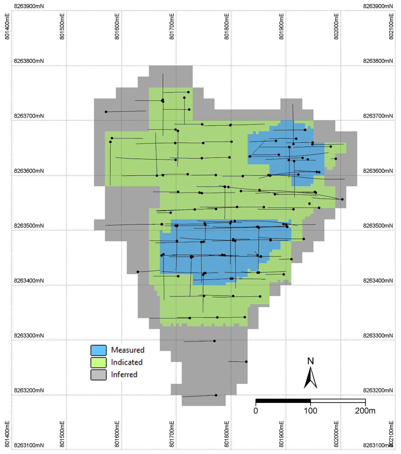
Mineral Resource and Mineral Reserve Estimates
In February 2019, Mkango announced an updated Mineral Resource estimate for the Songwe Hill deposit:
|
Songwe Hill Mineral Resource at 1.00% TREO cut-off grade |
|||
|
Category |
Tonnes |
TREO |
TREO tonnes |
|
Measured |
8.81 |
1.50 |
131.9 |
|
Indicated |
12.22 |
1.35 |
165.5 |
|
Total M&I |
21.03 |
1.41 |
297.4 |
|
Inferred |
27.54 |
1.33 |
366.2 |
The Mineral Resource is open at depth. The combined Measured and Indicated Mineral Resource Estimate, totalling 21 Mt grading 1.41% TREO, is the basis of the mine plan in the Definitive Feasibility Study, which evaluates a bulk tonnage, open pit mining operation focused on broad zones of near surface and outcropping rare earths mineralisation.
The Measured Mineral Resource Estimate comprises 42% of the combined Measured and Indicated Mineral Resource Estimate, providing geological confidence to support the Feasibility Study.
Approximately 95% of the Measured and Indicated Mineral Resource Blocks are at a depth of less than 160 m below the surface of the hill, indicating that the majority will be accessible by open pit mining.
For further details of the Mineral Resource estimates, please refer to the report titled ‘Mkango Resources Ltd Songwe Hill Rare Earth Element (REE) Project, Phalombe District, Republic of Malawi – NI 43-101 Technical Report – 23 January 2019 Mineral Resource Estimate’ which is available at www.sedar.com
Mining
The mine plan is being designed by Bara Consulting Ltd, based on a conventional open pit mining operation and assuming the use of a contract miner. The mine plan incorporates the use of stockpiles to manage the grade profile and maximise returns.
Processing and Metallurgical Testwork
Mkango produced a 60-tonne bulk sample after the Phase 3 drilling in 2018, selected from areas within the Measured and Indicated Mineral Resource Estimates. The bulk sample arrived in Fremantle, Australia, in August 2019 for metallurgical pilot test work.
Environmental, Social and Health Impact Studies
Feasibility environmental and social baseline studies are being conducted by Digby Wells Environmental in consultation with Malawian environmental specialists, based on the requirements of the Equator Principles, International Finance Corporation (IFC) Performance Standards as well as specific requirements and interpretations of Malawian Legislation as provided by their Department of Environmental Affairs (DEA). Base line studies continue at the exploration site, including water borehole monitoring and collection of monthly dust and climate data.
In terms of Corporate Social Responsibility, Mkango has taken the initiative to help the local communities through educational support to three primary schools, feeding programmes at two schools in collaboration with Zero Hunger With Nishkam Langar, secondary school scholarships, provision and repair of water boreholes, and repair and construction of roads and bridges.