Thambani U-Ta-Nb
Introduction
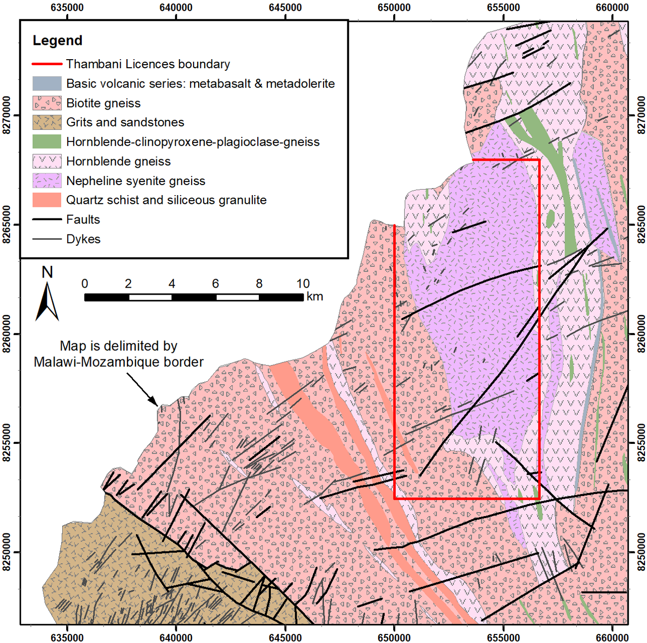
The Thambani licences, located in the Mwanza District of southwestern Malawi, was granted by the Malawi Ministry of Natural Resources, Energy and Environment on 10th September, 2010 in respect of an area of 468km2. In September 2013, September 2015 and September 2017 the Government of Malawi granted further two-year renewals for the licence. At the second renewal the Company requested a reduction in the licence size to 136.9km2. In October 2021, the exploration licence was converted to a block of four retention licences with a combined area of 98.36km2 which Mkango refers to as the 'Thambani Licences'.
Mkango is currently evaluating strategic options for Thambani, including opportunities to joint venture or spin off the project, and other potential avenues to create value.
Location
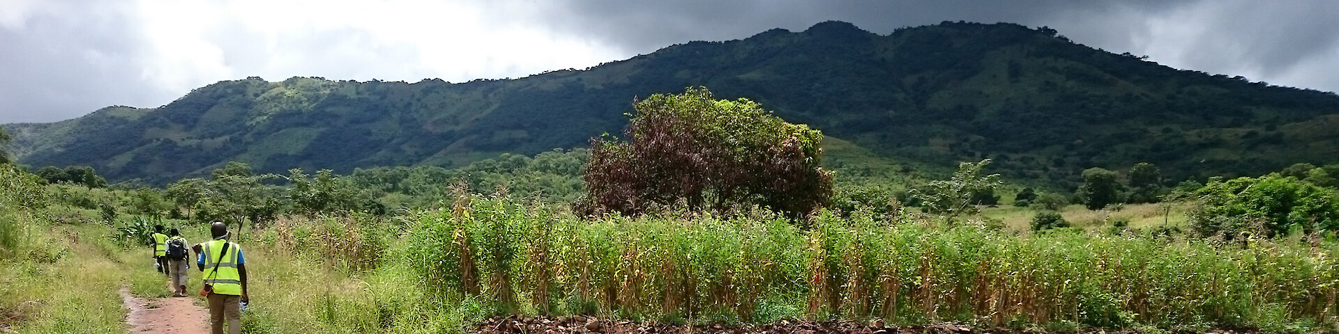
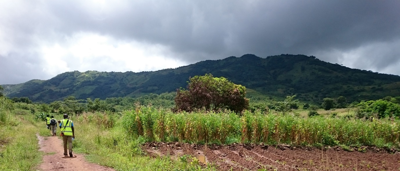
The Thambani licence is located in the Southern Region of Malawi, within the Mwanza District in the northern part of the licence and the Chikwawa District in the south. It lies approximately 120km west of Blantyre (capital of finance and commerce) which is served by Chileka International Airport, and about 30km from the large town of Mwanza, the administrative headquarters of Mwanza District, which lies on the main road from Blantyre to Tete in Mozambique. Thambani is the main trading centre within the licence. Secondary gravel roads provide vehicle access from Mwanza town to the project area. Thambani trading centre is connected to the national electricity grid and is approximately 30km from the new Tete–Nacala railway which transverses southern Malawi, passing through the southern part of the licence.
General Geology
The geology of the Thambani area is dominated by paragneisses of the basement complex (Mozambique Belt of southern Malawi) with only the extreme south-west of the licence crossing the Mwanza Fault into the Palaeozoic Karoo sediments. The majority of the licence area is underlain by metasediments, mostly biotite gneiss, in which the gneissose fabric trends NW-SE in the southern part of the licence and rotates to NNW-SSE in the north-west quadrant of the licence area.
The north-east of the Thambani licence is dominated by a large body of nepheline syenite gneiss, known as the Thambani Massif, which forms the Thambani East and West Ridges and much of the valley in between, and is approximately 75 km2 in area. The syenite gneiss is metamorphosed, has a west-dipping foliation, and includes bands and schlieren of biotite oriented parallel to the foliation in the the surrounding rock. Mineralogically, the gneiss consists of variable proportions of plagioclase, nepheline, biotite, muscovite, and zircon, with or without accessory corundum, apatite, magnetite and calcite; also disseminated betafite. Other minerals described from the Thambani Massif include columbite and molybdenite.
Exploration
Mkango's exploration activities to date include acquisition of Landsat7 and ASTER satellite imagery for the licence area, systematic ground radiometric surveys to confirm and detail known airborne anomalies, reconnaissance geological mapping, trenching, and litho-geochemical sampling programmes. The work has identified a number of potential uranium and associated niobium-tantalum targets over the Thambani Massif.

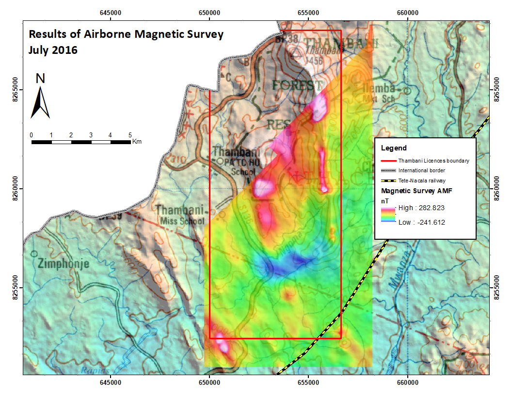
Airborne Radiometric and Magnetic Surveys
In 1984 and 1985 the Geological Survey Department of Malawi (GSDM) compiled and published total field aeromagnetic survey data at 1:250,000, 1:100,000 and 1:50,000 scales covering the whole of Malawi. The data were acquired by Hunting Geology and Geophysics Ltd (“Hunting”) under contract to the United Nations (Project MLW/ 80/030) (Hunting Geology & Geophysics Limited, 1985). The data were obtained, dependent on the terrain, from fixed wing and helicopter aeromagnetic surveys flown with a flight line spacing of 1,000m at mean sensor elevations of 120m and 50m, respectively. The data were corrected for diurnal variations and gridded at a cell size of 250m prior to contouring for the paper-based maps. Topographic information was reproduced from the 1:50,000 scale map series published by the Government of Malawi using a Universal Transverse Mercator (“UTM”) coordinate grid.
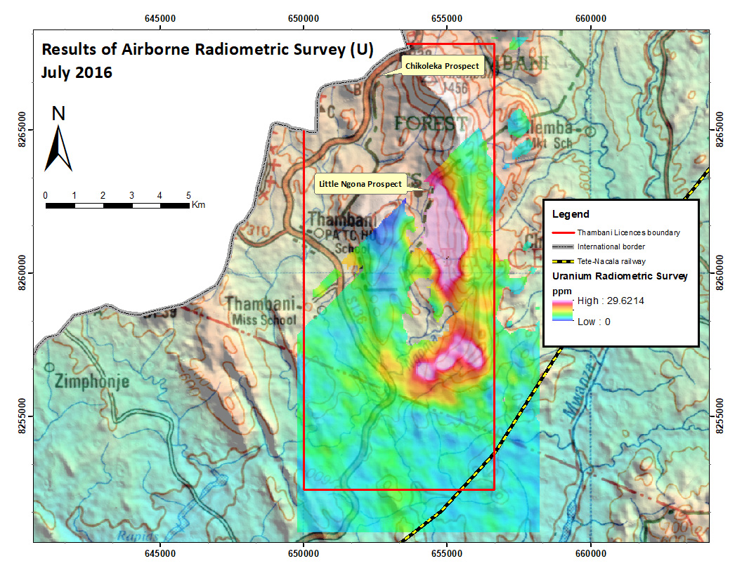
Country-wide radiometric data was also acquired during 1984 (Hunting Geology and Geophysics Limited, 1985) and published by the GSDM as a series of 1:250,000, 1:100,000 and 1:50,000 scaled maps. The maps show total counts, uranium, potassium and thorium counts and ternary colour plots, available at 1:100,000 and 1:250,000 scales.
The Thambani area was one of six key areas subject to subsequent geological ground investigations and considered to have potential for economic uranium mineralisation.
Ground Radiometric Survey
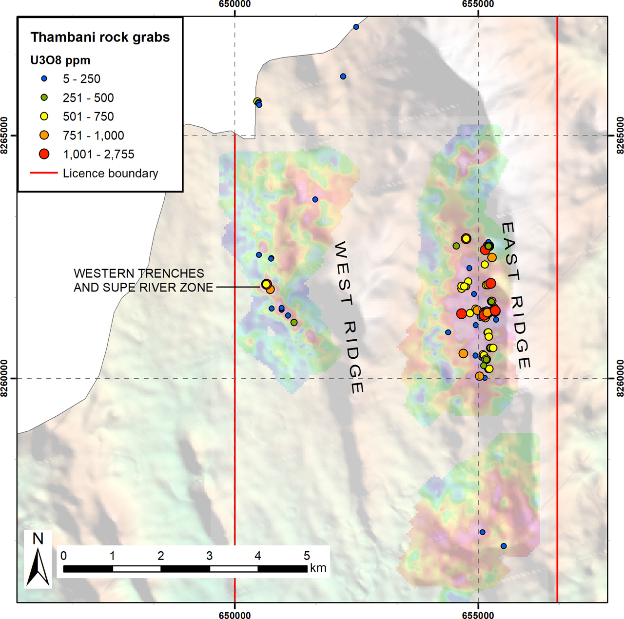
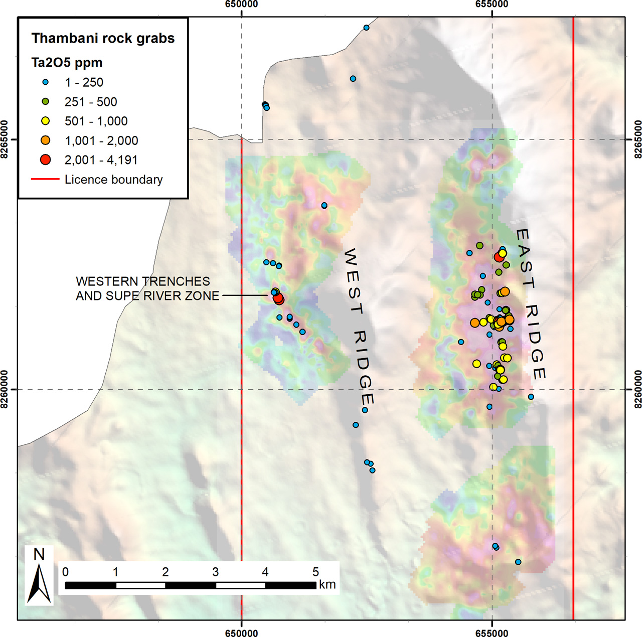
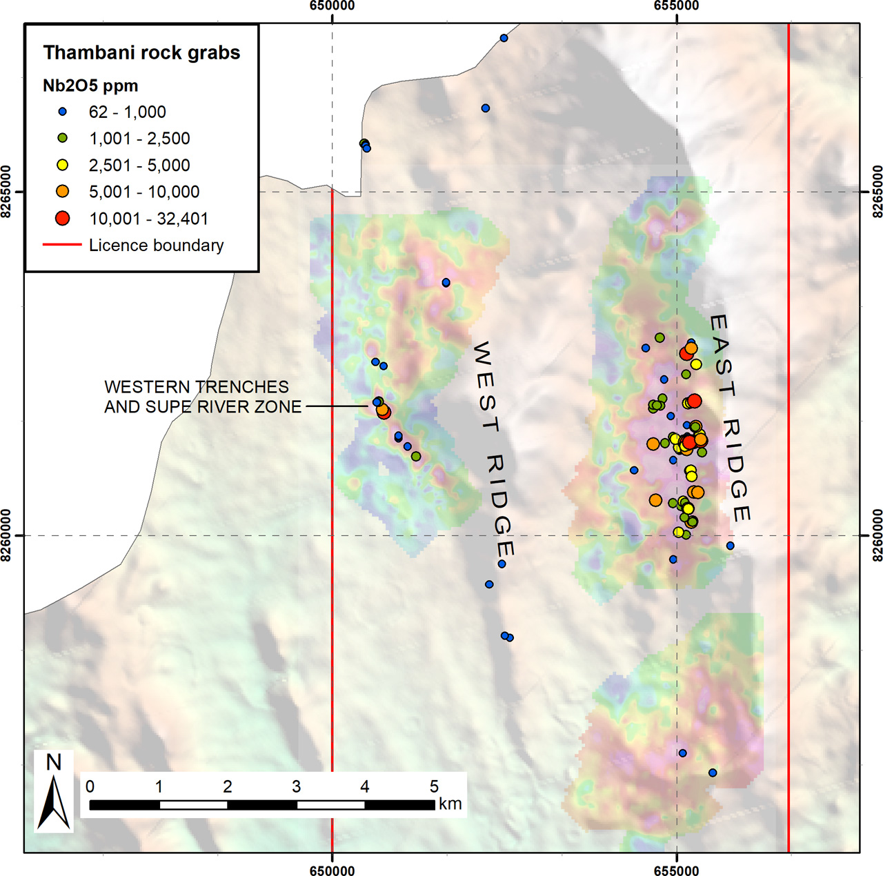
A systematic ground radiometric survey completed by Mkango confirmed and detailed two distinct uranium anomalies, occurring along the East Ridge and at the western foot of the West Ridge. A strong uranium anomaly, measuring approximately 3km by 1.5km, occurs along the length of the Thambani East ridge, with a north-south trend, and a second uranium anomaly, measuring approximately 1.5km by 0.4km, occurs at the foot of the West Ridge along or close to the western contact of the nepheline syenite body with a large body of biotite-hornblende gneiss that outcrops to the west. Most of the uranium ‘hot spots’ within these anomalous areas have been ground-truthed and sampled.
An airborne magnetic survey revealed a strong, thin anomaly along the crest of the East Ridge. A wider magnetic anomaly occurs along the West Ridge. It appears that the radiometric uranium highs and the magnetic highs occupy mutually exclusive areas.
Sampling Programmes
In 2013, Mkango completed a sampling programme across the Thambani Massif primarily focused on two sites of historical uranium exploration, known as the Chikoleka and Little Ngona targets. An initial set of 9 historical trenches, selected on the basis of anomalous ground radiometric measurements, were cleaned, re-examined and sampled across profiles from soil/overburden into bedrock. Some outcrop was also sampled on the East Ridge.
In 2017, Mkango revisited the trenches at Little Ngona and Chikoleka and carried out new work on the East Ridge and at the foot of the West Ridge. The main objectives of the programme were to confirm the grades of previously identified high grade mineralisation at the Little Ngona target, ground-truth new geophysical targets and complete further reconnaissance sampling along the East and West Ridges.
Assay results in 2017 were notably higher than results from the 2013 reconnaissance surface geochemical sampling programme. New areas of uranium, tantalum and niobium mineralisation were identified at the foot of the West Ridge and on the East Ridge. Most significantly, a radiometric high at the foot of the West Ridge yielded two of four highest grade samples (U3111 and U3183 in Tables 1 and 2 below) in this phase of exploration.
In 2019, Mkango identified new areas of outcropping mineralisation through further geological reconnaissance and sampling, mainly along the East Ridge but also in the Supe River in the west. Ten new trenches were excavated: three at the western foot of the West Ridge (the Western Trenches) and seven trenches in radiometric anomalies at widely separate locations along the foot of the East Ridge.
Results associated with the 20 best U3O8 assays of trench samples from the combined field programmes are summarised in Table 1, and the 20 best U3O8 assays of rock grab samples in Table 2.
| Trench ID | Profile | Sample ID | From (m) | To (m) | Description | U3O8 ppm | Ta2O5 ppm | Nb2O5 ppm |
|---|---|---|---|---|---|---|---|---|
| Chikoleka trench 3 | A | U3622 | 0.5 | 1.0 | Soil | 50,656 | 3,763 | 35,488 |
| East Ridge CEGB(?) trench | U3141 | Biotite-rich feldspathic rock | 32,590 | 19,029 | 59,200 | |||
| Western trenches pit 3 | U3183 | Weathered biotite-banded syenite gneiss | 31,812 | 15,224 | 60,055 | |||
| Little Ngona trench 11A | U3136 | Pink feldspathic rock | 10,131 | 4,845 | 32,478 | |||
| Western trench 3 | T0567 | Decomposed nepheline syenite gneiss | 7,369 | 3,849 | 12,933 | |||
| Little Ngona trench 12 | U3127 | Highly weathered feldspathic rock | 5,468 | 3,084 | 15,138 | |||
| Little Ngona trench 11A | U3135 | Pink feldspathic rock | 5,265 | 2,747 | 13,183 | |||
| Little Ngona trench 10 | U3122 | Highly weathered feldspathic rock | 5,250 | 2,431 | 10,820 | |||
| Little Ngona trench 11 | U3125 | Highly weathered feldspathic rock | 4,518 | 2,028 | 8,461 | |||
| Little Ngona trench 11 | U3115 | Heavily weathered feldspathic rock | 4,352 | 2,221 | 9,789 | |||
| Little Ngona trench 11 | C | U3508 | 0.5 | 1.0 | Decomposed feldspathic rock | 4,228 | 743 | 7,805 |
| Little Ngona trench 10 | U3121 | Heavily weathered feldspathic rock | 4,191 | 2,390 | 13,585 | |||
| Little Ngona trench 11A | U3137 | Pink weathered feldspathic rock | 3,988 | 1,896 | 8,707 | |||
| Little Ngona trench 11 | U3124 | Highly weathered feldspathic rock | 3,952 | 2,100 | 9,600 | |||
| Little Ngona trench 12 | U3129 | Weathered pink feldspathic rock | 3,562 | 1,625 | 6,469 | |||
| East Ridge CEGB(?) trench | U3176 | Biotite-rich band in feldspathic rock | 3,264 | 1,905 | 5,864 | |||
| Little Ngona trench 11 | U3131 | Highly weathered feldspathic rock | 2,768 | 1,293 | 5,314 | |||
| Little Ngona trench 11 | C | U3509 | 1.0 | 1.5 | Decomposed feldspathic rock | 2,537 | 911 | 6,619 |
| Little Ngona trench 11 | B | U3505 | 0.5 | 1.0 | Decomposed feldspathic rock | 2,367 | 972 | 5,424 |
| Little Ngona trench 4 | U3133 | Heavily weathered feldspathic rock | 2,231 | 1,235 | 5,971 |
Table 1. Assays of the 20 highest-grade U3O8 samples from the Thambani trench sampling programme
| Sample ID | U3O8 ppm | Ta2O5 ppm | Nb2O5 ppm | Description |
|---|---|---|---|---|
| U3111 | 8,826 | 4,191 | 14,871 | Quartzvein |
| U3168 | 3,664 | 2,022 | 7,137 | Biotite-rich |
| G1902 | 2,755 | 4,057 | 32,401 | Nepheline syenite |
| G1951 | 2,254 | 2,152 | 14,713 | Nepheline syenite |
| G1928 | 2,028 | 2,450 | 17,516 | Nepheline syenite |
| G1962 | 1,880 | 1,561 | 8,634 | Nepheline syenite |
| U3172 | 1,749 | 1,351 | 3,924 | Nepheline syenite |
| G1837 | 1,546 | 444 | 1,657 | Nepheline syenite |
| G1938 | 1,483 | 29 | 305 | Nepheline syenite |
| G1903 | 1,409 | 2,305 | 19,451 | Nepheline syenite |
| U3171 | 1,382 | 862 | 2,785 | Nepheline syenite |
| G1929 | 1,333 | 1,886 | 14,764 | Nepheline syenite |
| G1946 | 1,275 | 855 | 3,126 | Nepheline syenite |
| G1961 | 1,239 | 1,698 | 12,823 | Nepheline syenite |
| U3112 | 1,212 | 1,322 | 12,066 | Nepheline syenite |
| G1931 | 1,164 | 1,397 | 10,322 | Nepheline syenite |
| G1964 | 1,041 | 1,161 | 9,921 | Nepheline syenite |
| G1945 | 1,030 | 1,092 | 7,434 | Nepheline syenite |
| G1963 | 963 | 1,328 | 10,885 | Nepheline syenite |
| G1925 | 948 | 816 | 3,822 | Nepheline syenite |
Table 2. Assays of the 20 highest-grade U3O8 samples from the Thambani rock sampling programme
Table 3 below summarises the assays of all rock grab and trench samples collected at Thambani. The values indicate that grades in the fresh rock tended to be higher, suggesting extensive secondary remobilisation of the elements of interest.
| Rock grab samples | Trench samples | |||||
|---|---|---|---|---|---|---|
| U3O8 | Ta2O5 | Nb2O5 | U3O8 | Ta2O5 | Nb2O5 | |
| Average | 574 | 488 | 3,201 | 974 | 432 | 2,063 |
| Median | 364 | 292 | 1,422 | 98 | 75 | 557 |
| Minimum | 1 | 2 | 17 | 3 | 1 | 17 |
| Maximum | 8,826 | 4,191 | 32,401 | 50,656 | 19,029 | 60,055 |
Table 3. Summary of assays (grades in ppm) for 127 rock grab samples and 253 trench samples collected during the 2013, 2017 and 2019 sampling programmes at Thambani
Exploration by Mkango at Thambani has provided new information on the nature, disposition and grade ranges of mineralisation in the Thambani Massif. Sampling of mainly fresh samples on the East Ridge indicates that the U-Ta-Nb mineralisation occurs within the gneissic bands, and surface observations indicate that it may occur in conformable zones. This provides a target for shallow drilling on the down-dip extension of the surface showings.
Sample preparation and analytical work was carried out by Intertek-Genalysis Laboratory Services (Johannesburg, South Africa and Perth, Australia) employing a fusion method using a sodium peroxide flux, with Inductively Coupled Plasma Mass Spectrometry (“ICP-MS”) and Inductively Coupled Plasma Optical Emission Spectrometry (“ICP-OES”) finish, and following strict internal QAQC procedures including the insertion of duplicates, blanks and certified standards. Mkango inserted standards and blanks at a frequency of 1 in 20 (5%).
Genalysis is accredited by The National Association of Testing Authorities Australia (“NATA”) to operate in accordance with ISO/IEC 17025, which includes the management requirements of ISO 9001: 2000. The Perth facility is accredited in the field of Chemical Testing for the tests shown in the Scope of Accreditation issued by NATA (Date of Accreditation: 20 September 1991).
Mineralogy
Preliminary mineralogical studies carried out on rock samples from the Little Ngona and Chikoleka trenches, using a scanning electron microscope at the Natural History Museum London, indicate that pyrochlore group minerals, mainly betafite, are the principal carriers of U, Nb and Ta in these samples.