Nkalonje Hill rare earths
Introduction
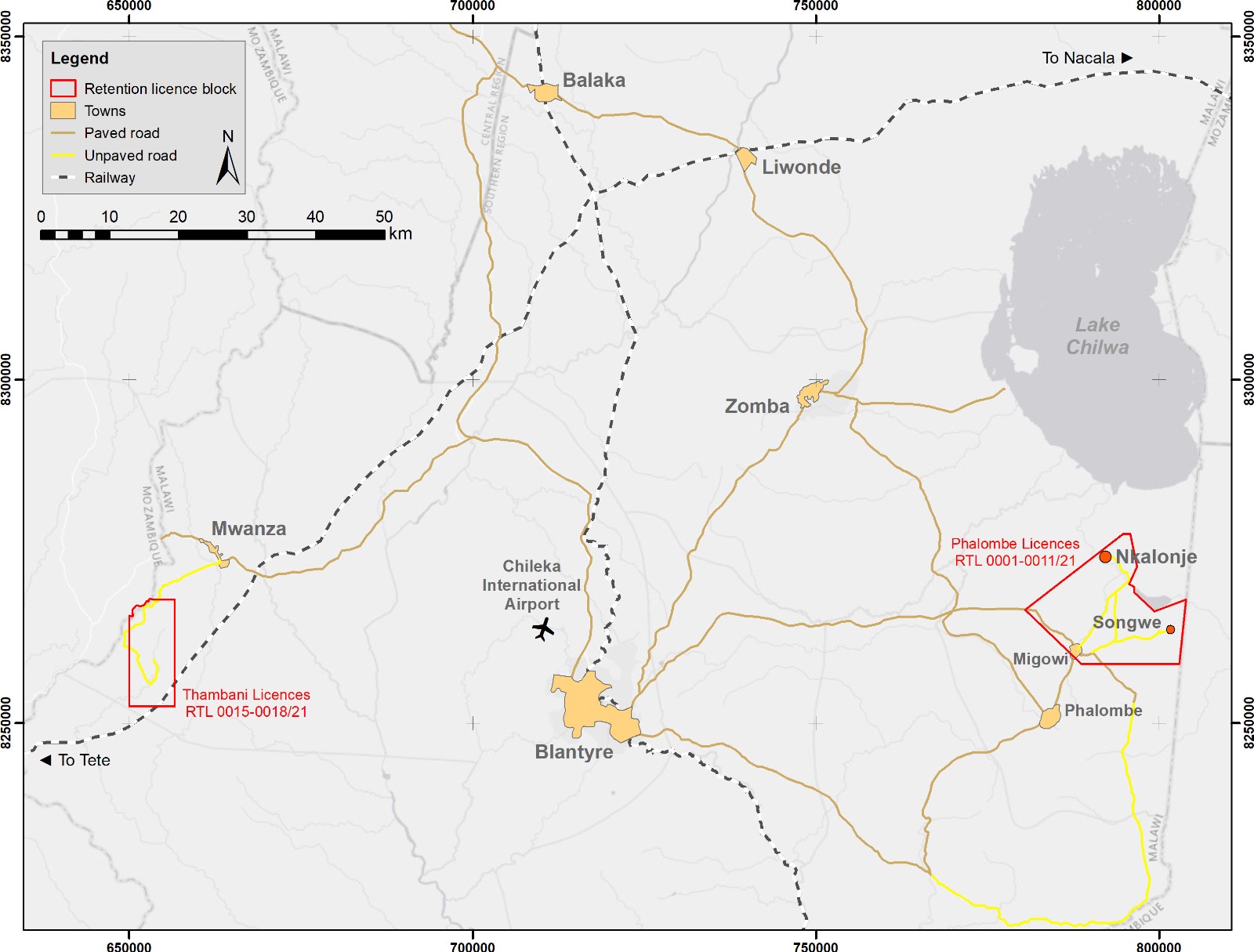
Nkalonje Hill is a carbonatite-hosted rare earth target located 14 km northwest of Mkango’s Songwe Hill Rare Earths Project, in retention licence RTL 0003/21, one of a block of eleven retention licences which Mkango refers to as the 'Phalombe Licences'. Historical mapping and sampling was carried out at Nkalonje Hill in 1961 and in the 1980s. Mkango completed initial sampling and ground geophysics in November–December 2021.
Location
Nkalonje Hill is located in southeastern Malawi, south of Lake Chilwa, approximately 95 km by road from the commercial capital of Blantyre, which has an international airport and a railhead (Figure 1). Paved roads run from Blantyre to within 19 km of Nkalonje.
Geology and mineralisation
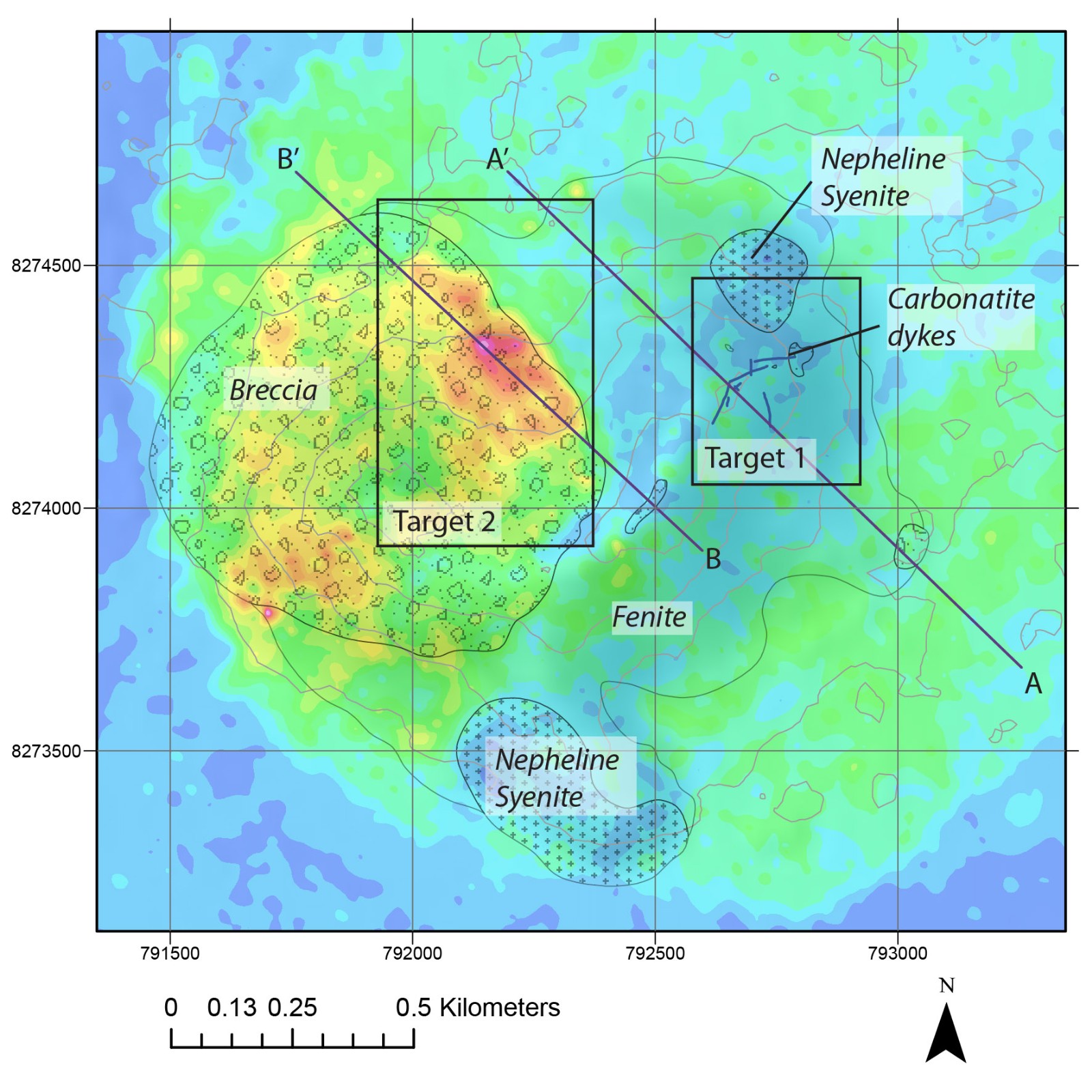
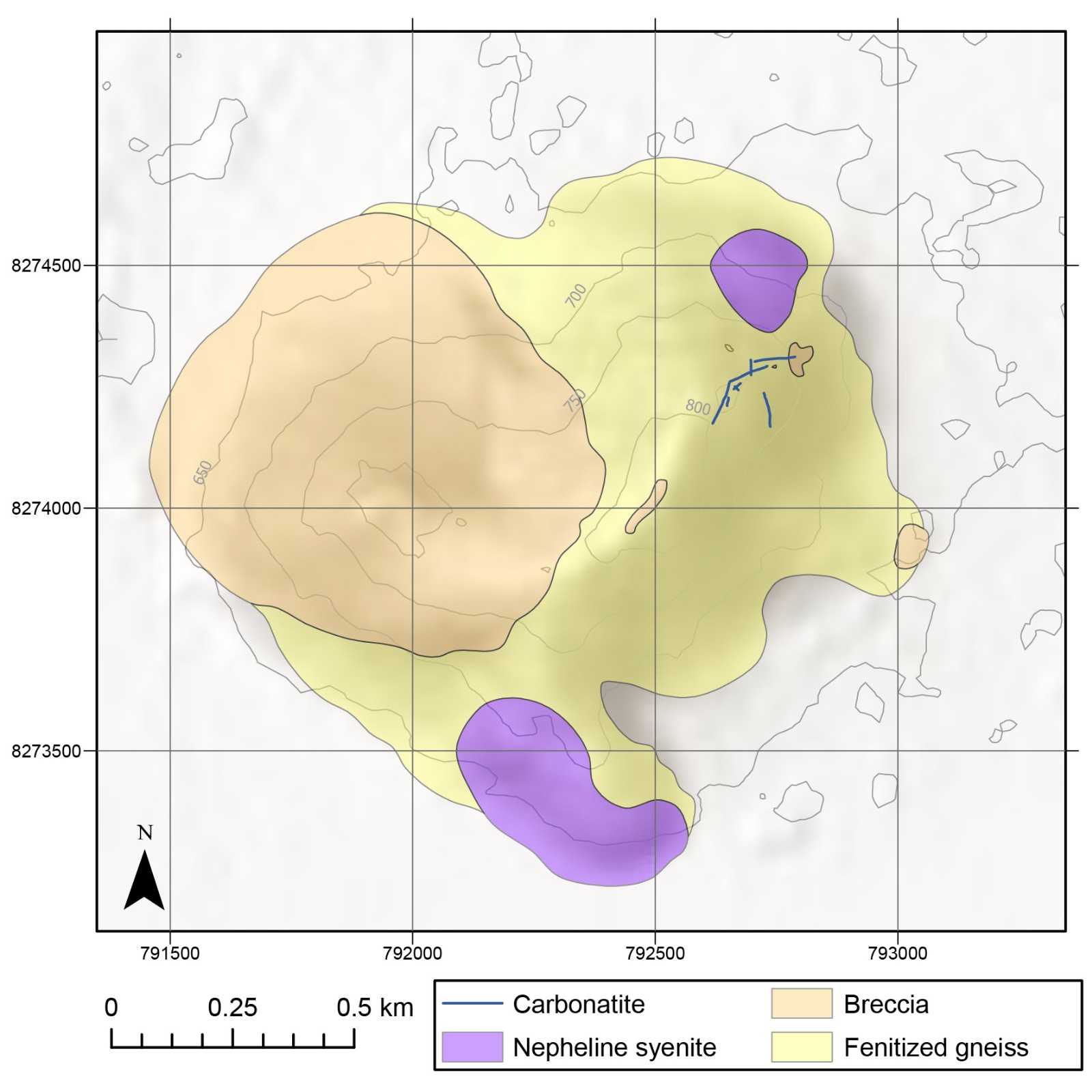
Nkalonje Hill is underlain by an alkali silicate–carbonatite intrusive complex geologically similar to Songwe Hill, comprising two connected peaks (Nkalonje and Nyama) underlain by fenite, nepheline syenite and breccia (Figure 2). The fenites on Nkalonje Hill are intruded by carbonatite veins and dykes that are locally enriched in rare earth elements (REE), suggesting potential for a larger mineralised carbonatite body below surface. The breccia body is approximately 900 m in diameter and comparable in lateral extent to Songwe Hill. Mapping to date has identified eight carbonatite dykes reaching 4 m in width and traceable at surface up to 90 m along strike.
Historical work
Up to and including the 1960s, the Geological Survey of Malawi carried out the initial geological investigations at Nkalonje Hill. The hill was first described in an unpublished report, dated 1909, by A.R. Andrew and T.E.G. Bailey. In 1937, a brief account of the geology of the hill was included in a bulletin on the Chilwa Series of southern Malawi, authored by F.W. Dixey and others. A revision of the bulletin was issued in 1955 but the account of Nkalonje Hill was unchanged. In 1952, the hill was mapped by M.S. Garson on a scale of 1:10,000. A detailed resurvey in 1956 revealed the presence of thin dykes of calcite carbonatite and ferroan carbonatite. This work was reported by Garson in 1961, with a summary included in Bulletin 15 of the Geological Survey Department titled ‘Carbonatites in Southern Malawi’ in 1965.
In the 1980s, the Japanese International Cooperation Agency (JICA) carried out independent mapping and collection of 35 samples from the longest exposed carbonatite dyke at Nkalonje, returning up to 0.58% ppm La (lanthanum) in the assays. The many trenches observed around this and other dykes may have been excavated by JICA. Nine samples were collected by JICA from other lithologies elsewhere on the hill.
Regional geophysical data from the World Bank-funded airborne programme in 2016 demonstrates that Nkalonje Hill is marked by a magnetic low and thorium high. Thorium radiometrics are a highly effective tool for rare earths exploration and target selection and the Songwe Hill carbonatite is also characterised by a thorium radiometric anomaly.
Recent exploration
Mkango completed reconnaissance mapping, sampling and ground geophysics at Nkalonje Hill in November–December 2021, following up on the encouraging historical regional geophysical data and JICA assay data. Geological mapping confirmed the presence of previously mapped nepheline syenite, breccia and carbonatite and showed that the basement gneisses in this area are highly fenitised. Combined mapping and geophysics results confirm that the major geological features of Nkalonje Hill are those of an alkali silicate-carbonatite intrusive complex, similar to Songwe Hill.
Two different carbonatite types are noted at Nkalonje Hill: (1) calcite carbonatite and (2) a banded ferroan calcite carbonatite. Assay results for 12 calcite carbonatite and 17 ferroan calcite carbonatite grab samples returned total rare earth oxide (TREO) grades of up to 5.92%, with a median value of 2.96% in the ferroan calcite carbonatite, suggesting concentration of the rare earth elements in the more evolved carbonatite phases.
| La₂O₃ | Ce₂O₃ | Pr₆O₁₁ | Nd₂O₃ | Sm₂O₃ | Eu₂O₃ | Gd₂O₃ | Tb₄O₇ | Dy₂O₃ | Ho₂O₃ | Er₂O₃ | Tm₂O₃ | Yb₂O₃ | Lu₂O₃ | Y₂O₃ | TREO | ||
|---|---|---|---|---|---|---|---|---|---|---|---|---|---|---|---|---|---|
| Ferroan calcite carbonatite n=17 |
Median | 7643 | 14134 | 1243 | 3224 | 240 | 57 | 120 | 17 | 102 | 22 | 69 | 11 | 72 | 10 | 762 | 2.96 |
| Max | 17197 | 29706 | 2767 | 7300 | 551 | 123 | 254 | 36 | 277 | 65 | 185 | 23 | 129 | 16 | 2101 | 5.92 | |
| Min | 4076 | 7571 | 695 | 1879 | 157 | 41 | 85 | 11 | 59 | 11 | 30 | 4 | 27 | 4 | 320 | 1.53 | |
| Calcite carbonatite n=12 | Median | 3343 | 5662 | 529 | 1557 | 150 | 35 | 82 | 12 | 56 | 10 | 28 | 4 | 23 | 4 | 275 | 1.20 |
| Max | 5474 | 8811 | 781 | 2172 | 204 | 50 | 109 | 15 | 75 | 14 | 36 | 5 | 31 | 4 | 423 | 1.80 | |
| Min | 1089 | 1874 | 169 | 480 | 55 | 16 | 40 | 6 | 32 | 6 | 19 | 3 | 16 | 2 | 191 | 0.40 | |
| Breccia | Sample P1817 | 707 | 1263 | 133 | 429 | 57 | 14 | 38 | 5 | 26 | 5 | 14 | 2 | 14 | 2 | 133 | 0.28 |
| Sample P1818 | 144 | 291 | 27 | 92 | 16 | 5 | 17 | 4 | 20 | 4 | 10 | 1 | 7 | 1 | 107 | 0.07 |
Table 1: Assay results for grab samples from the Nkalonje Hill Rare Earths Project. Grades for individual rare earth oxides reported in parts per million (ppm), total rare earth oxides (TREO) in weight percent.
Sample preparation and analytical work was provided by Intertek-Genalysis Laboratories (Johannesburg, South Africa, and Perth, Australia), employing ICP-MS techniques suitable for REE analyses and following strict internal laboratory QAQC procedures, inserting blanks, standards and duplicates, in addition to blanks and standards inserted by Mkango.
Ground geophysics data was acquired over Nkalonje Hill by Gregory Symons Geophysics (Namibia) in November-December 2021. Ground magnetic, radiometric and gravity data were collected over an area of 2.7 x 2.7 km, covering the hill and surrounding lake sediments, with magnetic and radiometric data collected at 50 m line spacing, and gravity data collected along selected lines at 100 m spacing. 3D inversions of the magnetic and gravity data were processed using VOXI Earth Modelling in Oasis Montaj software. Natural Source Audio Magneto-Telluric (NSAMT) data was acquired on two lines, one northwest to southeast, the other northeast to southwest, bisecting the hill at 50 m station spacing, and an Induced Polarity (IP) survey was carried out using a pole-dipole electrode spread on eight lines with a 50 m dipole spacing.
The ground geophysics data support the geological interpretation of a ring complex structure, as seen at Songwe, and at other carbonatite vents in Malawi. The overall diameter of this structure is approximately 1.7 km and comprises an outer ring of nepheline syenite and a central vent of breccia. The geophysical characteristics of the central breccia vent include a low magnetic response, low density and high conductivity. However, it also includes a central gravity anomaly extending from the surface to approximately 300 m depth. This feature is preliminarily interpreted as a shallow body of carbonatite, which fits the observed lithologies present at Nkalonje, and the conceptual structure of the hill.
Exploration targets
Based on interpretation of the recent data, two exploration targets have been identified at Nkalonje:
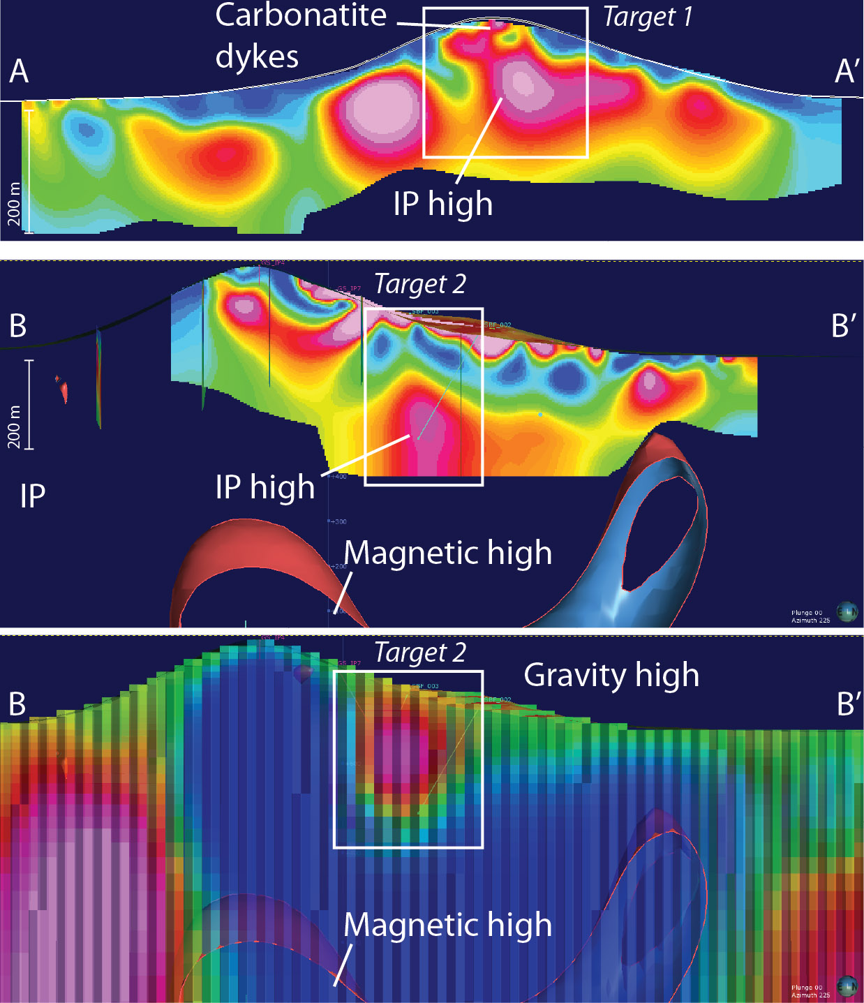
Target 1 is centred on known mineralisation hosted by the carbonatite dykes. Further mineralisation at depth is interpreted from IP geophysical anomalies which present a series of potential shallow drill targets extending down-dip of the exposed dykes (Figures 3 and 4).
Target 2 is a conceptual target based on geophysical anomalies which consist of a surface radiometric anomaly (high Th), a gravity high and magnetitic low, with an IP anomaly at depth (Figures 3 and 4). The target is in a relatively eroded, poorly exposed part of the hill. These geophysical and geomorphological features fit with a conceptual model of a central carbonatite body, common to other carbonatite complexes, which the surface dykes suggest may potentially contain REE mineralisation.
Planned work at Nkalonje consists of continued evaluation of the dykes at Target 1, including new sampling (including channel sampling where possible) in order to trace the grade of the dykes along strike. A soil/auger sampling and trenching programme is planned to ground truth the geophysical anomalies at Target 2.
In the long term, the close proximity of Nkalonje to Songwe has the potential to provide additional higher-grade feedstock for processing at Mkango’s Songwe Hill rare earths project.